

We started making work in our home of St. Louis, home of the meeting of America's two greatest rivers.

Chouteau Island, Madison County, Illinois - January 2016
38° 45' 38.8578"N 90° 8' 50.769"W Elevation 420 Feet
Chouteau Island is the northern part of the land between the Chain of Rocks Canal and the wild stretch of the Mississippi River that separates Missouri from Illinois. You can see this agricultural and conservation area by looking down at the eastern end of the highway 270 bridge. More info
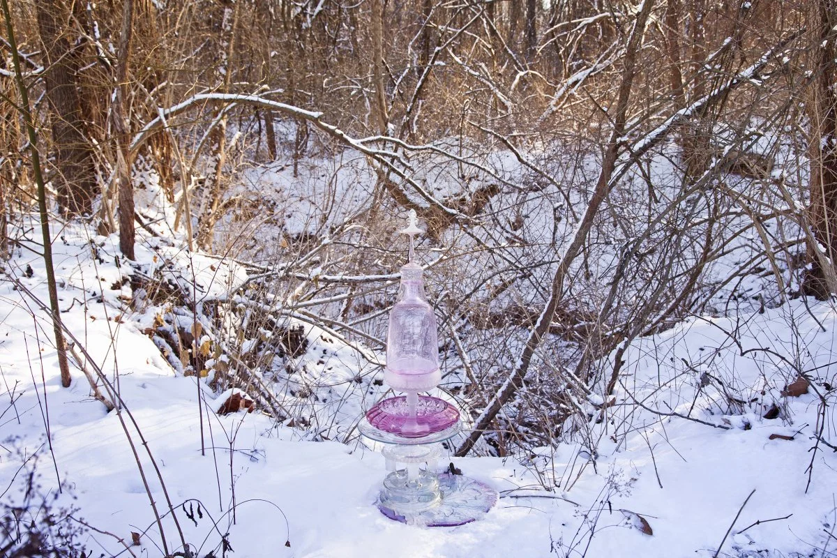
St. Louis Community College Florissant Valley, Ferguson, Missouri—January 2016
38°45'56.52"N 90°17'28.96"W
The Pink cairn rests in the snow at the edge of the creek in the western part of the St. Louis Community College, Florissant Valley campus.

14th Street Between Monroe and Clinton Streets, St. Louis, Missouri—September 2015
38°38'48.61"N 90°11'42.76"W
The FLOWer cairn poses on the rocky bed of the Old North Rain Garden that was installed in Summer 2013. The purpose of a rain garden is to slow down stormwater before it gets to Metropolitan Sewer District’s underground pipes.

North 40th Street and Morris Avenue, East St. Louis, Illinois—6 a.m., July 4, 2015
38°38'20.07"N 90° 6'31.29"W
This Metro East neighborhood of small to midsized homes is located near the Jackie Joiner-Kersey Youth Center, Jones Park, and the JJK Center MetroLink station. This photograph looks east in the very early morning as fog rises from a stream, flowing in the center of a long, freshly mowed park. A forest of trees separates this area from the railroad tracks to the north.

North 36th Street and Morris Avenue, East St. Louis, Illinois—7 a.m., July 4, 2015
38°38'18.08"N 90° 6'43.74"W Elevation 409 Feet
The Park Bridge Cairn is assembled from an odd collection of glass objects balanced on one of several bridges crossing the storm drainage channel that was once the meandering Schoenberger Creek.

Earl Widman County Park , 7730 Telegraph Rd. , St. Louis County, Missouri—March 2015
38° 25' 27.408"N 90° 20' 40.581"
The Tethys cairn that has been photographed following the water from the Courtois and Huzzah and into the Meramec is shown here 55 feet east of the bank of the Meramec at the southern edge of St. Louis County. This area was used as Widman County Park until repeated flooding (most recently in 2008, 2009 and 2010) made its maintenance too frequent and expensive.

Earl Widman County Park , 7730 Telegraph Rd. , St. Louis County, Missouri—March 2015
38° 25' 27.408"N 90° 20' 40.581"
The Tethys cairn is photographed in the water at Earl Widman Park. This area was a farm field, then became a rock quarry. Beginning in 1993, floodwater filled the quarry, creating this pond. Trash like the yellow lawn hose seen around the base of Tethys was washed into the water in the subsequent, frequent floods.

Layton Road, Madison County, Illinois—April 2015
38° 40' 55.9992"N 90° 6' 33.9978
Horseshoe Lake is the second largest natural lake in the State of Illinois. Formed centuries ago after a flood when the Mississippi River found a new channel across the bottomland and left this oxbow-shape lake to fend for itself.

Highway #3 Construction, Packer Avenue near St. Clair Avenue, National City, Illinois—May 2015
38° 38' 37.968"N 90° 9' 47.988"W
Looking west to the Gateway National Expansion Memorial, the Arch, This Bubble cairn rests in a ditch next to Highway #3 construction. The highway is being revamped and re-ramped to connect with the recently completed Stan Musial Veteran’s Memorial Bridge.

Fairground Park, St. Louis City, Missouri—October 2014
38° 40' 6.099"N 90° 13' 28.959"W
The Fair Ground cairn is placed between a trash and recycling bin behind a one-story pink building on the northwest corner of Fairground Park. The park’s rich, but largely forgotten, history illustrates how social, economic, and political conditions influence the watershed.
Devil’s Prop Nature Preserve, between Texico and Harmony, Illinois—January 2015
38°25'13.38"N 88°50'25.26"W
In his 1963 report Some Unusual Natural Areas in Illinois and a Few of Their Plants, Robert A. Evers addressed Devil’s Prop. He wrote, “At one place the small stream flows through a narrow, V-shaped ravine. In some places, the sandstone of the steep sides is exposed and in other places covered with a thin layer of soil."

Devil’s Prop Nature Preserve, between Texico and Harmony, Illinois—January 2015
38°25'13.38"N 88°50'25.26"W
Still Blue’s title was suggested by the tranquility of this rocky, wooded, and moss-covered natural area. The stillness was broken only by the sound of melting water as it gurgled into the ground beneath the frozen waterfalls. Occasionally, one of those massive icicles broke free from the rocky cliff and crashed, rumbling the ground under our feet.

Devil’s Prop Nature Preserve, between Texico and Harmony, Illinois—January 2015
38°25'13.38"N 88°50'25.26"W
The Still Blue cairn rests under the arm of the rock formation that gives Devil’s Prop Nature Preserve its name. The rock is unusual, but the entire ecosystem of bluff, stream, trees, and plants is a rare chance to see what the region was like before so much land was cleared for agriculture.

Wild Rose Farm, North Copple Lane, Dix, Illinois—October 2014
Private Property
In ancient mythology, Midas is given the power to turn everything he touches into gold, which makes him a very rich man. However, when he kisses his beloved daughter, she too turns into the cold, hard, valuable metal. This cairn uses the Midas story as a cautionary tale.

Veterans Memorial Park, Forest Ave., Mt. Vernon, Illinois— December 2014
38° 18' 17.0598"N 88° 55' 24.7506"W
A stalagmite is a natural stone tower built of minerals deposited by slowly dripping water on the floor of a cave. Here, more than 20 “stalagmite” cairns stand in a spillway, that looks like a shallow, manmade cave.

Cliff Cave Road, St. Louis County, Missouri—March 2014
38° 28' 4.0578" 90° 17' 12.9588" Elevation 655 Feet
The Tributary cairn overlooks the Bussen Quarry where limestone is mined. You can see the Jefferson Barracks Bridge and the Mississippi River in the distance, behind the 600-acre quarry site.

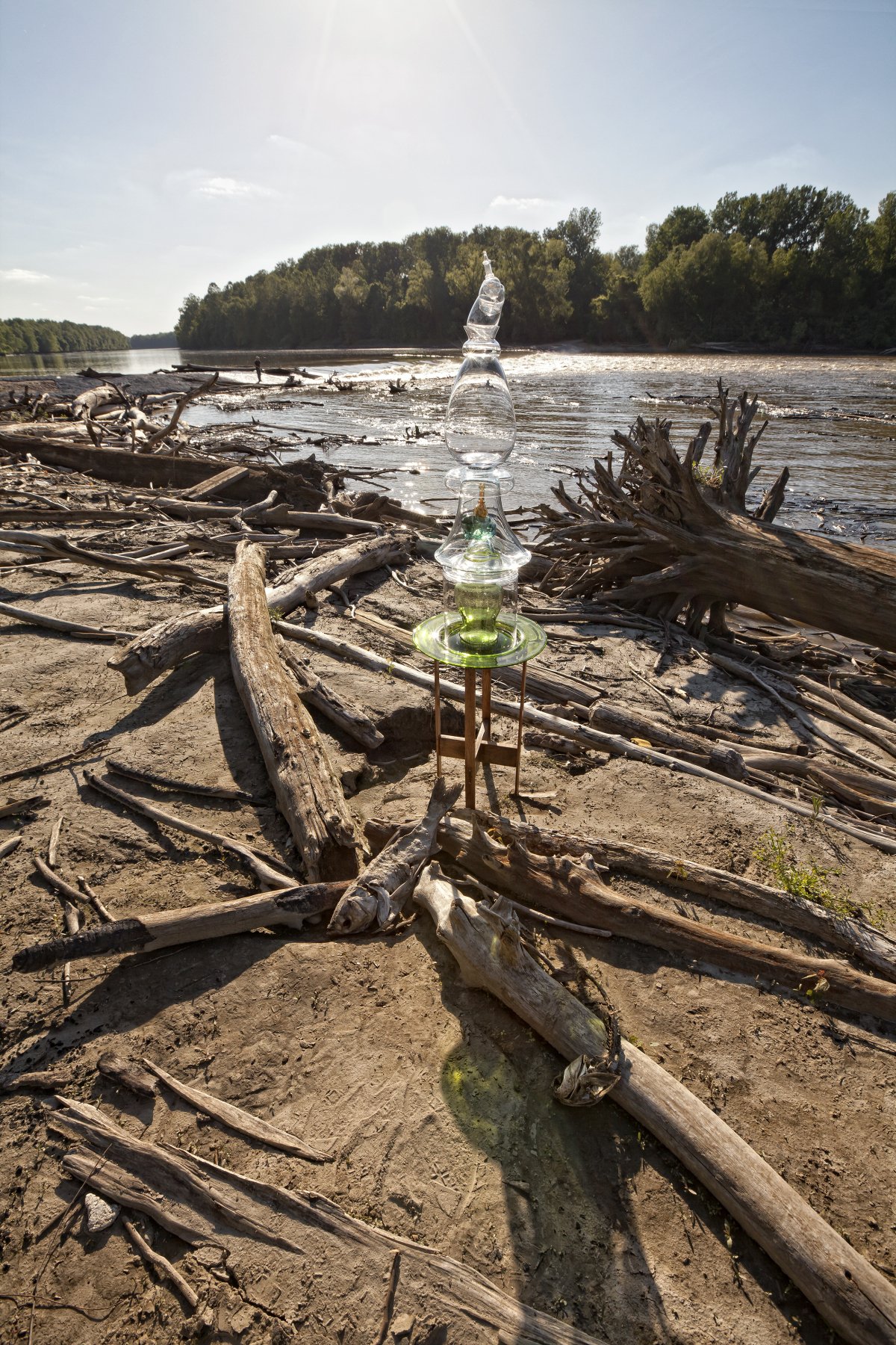
Meramec River, Leasburg, Missouri—August 2014
38° 3' 21.9204" 91° 13' 48.7488"
Tethys cairn, marking the Meramec River watershed in southwestern metropolitan St. Louis, rests on a stump where a small stream enters the river. A group of people-shy ducks were swimming nearby but refused to paddle into the photograph even when we tossed granola into the water.

Courtois Creek, Leasburg, Missouri—August 2014
38° 1' 46.6104" 91° 13' 15.7506"
The Tethys cairn, marking the Meramec River watershed in southwestern metropolitan St. Louis, is balanced on a “raft” of sticks caught by an island that is not much bigger than the beverage coolers in the passing canoes.

Meramec River at Route 66 State Park, 97 Outer Road East, No.1, Eureka, Missouri—August 2014
38° 30' 18.2694N 90° 35' 29.5002"W
Tethys cairn, marking the Meramec River watershed in southwestern metropolitan St. Louis, sits on a concrete foundation, all that remains of an early bridge, and in front of a more recently decommissioned Route 66 highway bridge.

Sanitary and storm sewer south of Forest Park, St. Louis, Missouri—April 2014
38° 37' 20.9784"N 90° 16' 17.5074"W, Elevation 457 feet
The blue-and-green-glass FLOWer Cairn sits in 6–12 inches of mostly rainwater on the curved floor of a 30-foot-diameter concrete tunnel. At intervals, grates in the bottom of the tunnel drain some of this ground water into the wastewater flowing in the sanitary sewers, below.

YMCA, 600 Loughborough Avenue, St. Louis, Missouri—June 2014
38° 33' 18.921"N 90° 15' 26.7012"W
Resting in an empty swimming pool at the historic Carondelet YMCA, a red- and clear-glass cairn supports a repurposed EXIT lamp on the top. The word EXIT has been replaced with the letters RIVR to remind us that the water we use in our homes, businesses, and swimming pools comes from the river and will return to the river.

Mill Creek Natural Area (near Piney Creek), Randolph County, Illinois—November 2013
37° 53' 42.6726"N 89° 39' 11.7066"W, Elevation 432 feet
This cairn marks a special place at the edge of an ancient glacier’s reach in Randolph County. Here, the sandstone canyons and gorges create a cool microclimate where club moss, cinnamon fern, and bishop’s cap have survived for eons.
Reservoir Park, South Grand Blvd., St. Louis, Missouri—January 2014
38° 36' 53.7438"N 90° 14' 19.1868"W
This birdbath-shaped cairn nests in the snow on the steps to the Compton Hill reservoir, adjacent to the 179-foot-tall Compton Hill Water Tower. A vintage ornament swirls through the Water Tower cairn to suggest water moving from the reservoir to the tower.

Florida and C streets, St. Louis, Missouri—October 2013
38° 38’ 23.49"N 90° 10' 56.32"W
Seven individual cairn sculptures are placed in the shape of the Big Dipper star constellation-pointing north. Most of the time, Illinois is east of Missouri, but because of a bend in the Mississippi River which divides the two states, Illinois is north at this point.

Granite City and Madison, Illinois—March 2013
38° 41' 4.9344"N 90° 11' 3.7386"W, Elevation 415 feet
Sixteen cairns, their shapes inspired by chess pieces, were placed on the site of the America’s Central Port’s new harbor, being constructed where the southern end of the Chain of Rocks Canal meets the Mississippi River.

Lewis and Clark Community College, Godfrey, Illinois—October 2013
38° 57' 7.4334"N 90° 11' 57.7104"W, Elevation 567 feet
China Creek Cairn is named for the broken pieces of dinnerware found in the creek bed on the Lewis and Clark Community College campus. The broken ceramics incorporated into the cairn and seen in the water have their origin in the college’s history, which began as the nation’s second college for women in 1838.

Lewis and Clark Community College, Grafton, Illinois—October 2013
38° 57' 7.4334"N 90° 11' 57.7104"W
China Creek is named for the broken pieces of dinnerware found in the creek bed on the Lewis and Clark Community College campus. The college began as a college for women in 1838. you can still see china with the Monticello logo in the water.

Sports Complex, Forestwood Park, Ferguson, Missouri-August 2012 38° 44' 17.8434"N 90° 17' 3.372"W, Elevation 461 feet
Rain in Forestwood Park falls on paved parking lots and dense turf that don’t allow water to seep into the ground. Instead, this stormwater washes litter, trash, automotive oil and antifreeze into an open, concrete-lined ditch along the edge of the park. The ditch drains into Maline Creek, which flows for miles through urban neighborhoods, picking up more trash before it enters the Mississippi River, south of the highway 270 bridge. .

Missouri American Water, 901 Hog Hollow Road, Chesterfield, Missouri- October 2012 38° 41' 7.926"N 90° 31' 22.872"
This cairn is poised on the Missouri American water intake, looking up the Missouri River toward the smokestack of the City of St. Louis Howard Bend Water Plant, reminding us that our drinking water comes from the rivers.

Mississippi Road near the Great River Road, Elsah, Illinois—June 2013
38° 57' 7.239"N 90° 21' 45.8886"W Elevation 430 Feet
When heavy rainfall in the Missouri, Illinois, and Mississippi watersheds combine, the Mississippi River backs up, pouring water into Elsah. This the second flood of the year.

Fairmont City, Illinois—April 2013
38° 38' 54.0846"N 90° 6' 32.7054"W
Most people don’t like algae—it’s slimy—but algae is a Green Goddess providing food for animals and nutrients for plants like these five-foot-tall grasses.

Multiple locations in Metro St. Louis—2012-2013
38° 36' 14.814"N 90° 13' 3.1326"W
Older cities like St. Louis have sewer systems with both sanitary and storm drainage routed through the same pipes including 100-year-old brick tunnel under this alley.

Forest Park, St. Louis, Missouri—November 2013
38° 38' 25.6596"N 90° 16' 17.8926”W
This cairn is made of glass cylinders, nestled inside one another, to mimic the growth rings of a tree. An actual tree gains one ring in each year of its life.

Mill Creek, Cobden, Illinois—March 2012
37° 34' 52.4994"N 89° 16' 15.636"W, Elevation 545
This cairn is named for the ancient Greek goddess. Gaia was the personification of the Earth and the mother of all the gods.

Frank Holten State Park, East St. Louis, Illinois—January 2014
38° 35' 49.9122"N 90° 6' 0.0504"W
Seven green-glass cairns rest on the ices between the knees of a solitary baldcypress tree at the edge of Whispering Willow Lake.

South Warf Street, St. Louis, Missouri—February 2013
38° 36' 35.7402"N 90° 11' 23.8452"W Elevation 412 Feet
These two cairns were photographed in an industrial area just south of the Gateway Arch north/upriver of the St. Louis Metropolitan Sewer District Miller Street Pumping Station when the river was low.

Sioux Passage Park, Missouri—August 2011
38° 51’ 3.1"N 90° 16' 38"W, Elevation 501 feet
Much of the St. Louis Region is built on karst, a limestone foundation that dissolves to create sinkholes, like this one near the Missouri River in North St. Louis County.
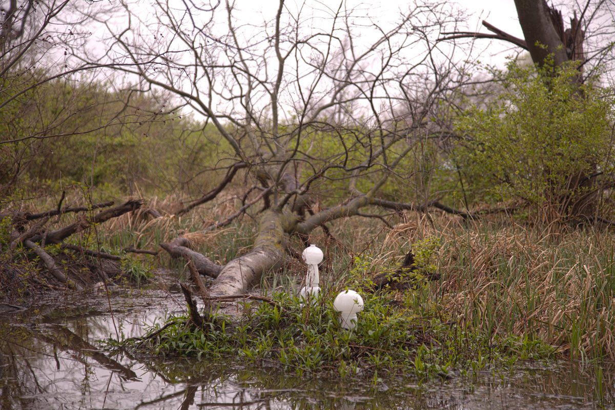
Madison Road near Mueller Lane, Madison County, Illinois—April 2013
38° 38' 31.6602" 90° 7' 31.1916"W
Two mushroom-shaped Kitchen Sink cairns rest alongside this stream in the Horseshoe Lake watershed. Wedged between an auto salvage yard and a giant landfill, this stream is struggling to survive.

Ulysses S. Grant National Historic Site, Crestwood, Missouri—October 2013
38° 33' 7.9344"N 90° 21' 7.491"W , Elevation 506
In African, and in the traditions of many cultures, libation (“LIE-bay-shun”) is the term for water or other clear liquid that is poured on the ground in memory of the deceased. In this image, the water of Prairie Creek, is pouring over the Libation Cairn in memory of the enslaved people who worked on President Grant's father-in-law’s farm.

White Cliffs Park, Crestwood, Missouri—October 2013
38°33'22.98"N 90°22'8.03"W
The Libation cairn stands at the edge of a historic quarry that provided the stone for many foundations and public buildings in the area from the late 1800s until the quarry began to fill with groundwater in the early 1900s.

Lewis and Clark Departure Memorial, Hartford, Illinois—May 2011
38° 48' 18.684"N 90° 6' 41.976"W, Elevation 418 feet
When Lewis and Clark launched their Journey of Discovery near this spot in May 1804, rivers were their roads, and oil came from plants and animals. Ironically, oil from distant wells is now transported in a pipeline on the creek bed at this site. .

Chain of Rocks Park, St. Louis, Missouri—March 2012
38°45'34.18"N 90°11'10.23"W, Elevation 480 feet
Fifteen blue- and clear-glass cairn sculptures stand on concrete steps in this north St. Louis city park, where water from the melted snow will flow to the Mississippi River.

St. Stanislaus Conservation Area, Hazelwood, Missouri—January 2013
38° 48' 50.5218"N 90° 23' 40.9446"W
A riparian buffer is an area of trees and grasses that shades the water and slows down runoff from adjacent land.

Audubon Center at Riverlands, West Alton, Missouri—March 2014
38° 52' 10.992" 90° 16' 56.8272"
The Lighthouse cairn is composed of green and clear glass. The clear vase on the top is in the shape of a man’s head. In his three-cornered hat is one of the many feathers found on the melting ice of Ellis Bay on the Mississippi River.

Under the Clark Bridge, West Alton, Missouri—March 2014
38° 52' 47.2296" 90° 11' 3.2562"
Posed below the Clark Bridge, looking east to the town of Alton, Illinois, the green- and clear-glass Lighthouse cairn marks the journey of human travelers across the river.

Castlewood County Park, Chesterfield, Missouri—October 2011
38° 19' 43.68"N 90° 19' 20.7474"
Cinderella, Rock-r-Fella cairn, assembled from a glass fish bowl, vases, and ashtrays, and containing rocks from the site, sits on a rusty, three-legged metal stool overlooking the Meramec River at Kiefer Creek.

Off Highway 3, Granite City, IL—January 2013
38° 43' 31.1874"N 90° 8' 57.6414"W
Like the almost invisible Sedge cairn, sedge plants, solid-stem grass-like vegetation are difficult to distinguish from true grasses, including lawn grasses and cultivated grains.

Off Highway 3,Granite City, IL—February 2013
38° 43' 26.0976"N 90° 8' 59.208"W
The Sedge cairn was photographed at dusk between a highway and railroad track to illustrate the ways we can pass very close to natural areas without seeing them.

Silver Creek Preserve, Mascoutah, Illinois—September 2013
38° 28' 12.759"N 89° 49' 29.769"W
A foggy dawn in the wetlands south of Mascoutah, Illinois reveals the green glass of the Silver Creek Spire cairn. Occasional jets from nearby Scott Air Force Base were only temporary interruptions to the croaking of frogs, the flittering of dragonflies and butterflies, and the sound of a small animal skittering through tall grasses.

Silver Creek Preserve, Mascoutah, Illinois—September 2013
38° 27' 55.044"N 89° 49' 2.964"W
This stream hides the Silver Creek Spire cairn and nourishes a multiplicity of wild plants, insects, and animals as it flows between Brickyard Lane and a farmer’s field.

Silver Creek Preserve, Mascoutah, Illinois—September 2013
38° 27' 45.828"N 89° 49' 38.586"W
The Silver Creek Spire was created for this tree in a seasonal streambed at the midpoint on the paved trail around Silver Creek Preserve. It was only after we began showing the image to friends that we learned the story behind this unusual tree shape.

Stemler Cave, Columbia, Illinois—July 2012, Private property near Stemler Trail
Some streams drop below the ground’s surface. Other streams begin as springs, deep in caves. Ultimately the water all reaches its river destination.
Howell Island Conservation Area, Chesterfield, Missouri—May 2012
38° 39' 52.1994"N 90° 40' 46.6314"W
The title of this piece refers to the genetic mutations occurring in frogs and fish in rivers where high concentrations of hormones and chemicals from prescription drugs have been detected.

Cliff Cave County Park, St. Louis County, Missouri—July 2011
38°27'36.06" N 90°17'13.16" W, Elevation 393 feet
A small, unnamed stream flows through eroded banks into the Mississippi River on a sunny day in south St. Louis County.

Rockford Beach, Big River, Jefferson County, Missouri—September 2013
38° 25' 18.339"N 90° 35' 19.2624"W
Although the mines of Missouri’s Old Lead Belt have closed, the water in the Big River is contaminated with lead and zinc from the chat (waste mineral ore). Fish in these waters have higher concentrations of lead in their bodies than in nonmining areas, and some wildlife, especially fish-eating birds like herons and egrets, may be adversely affected.

Greenmount & Frank Scott, Shiloh, Illinois—Oct. 2011
38° 34' 9.372"N 89° 55' 46.4154"W
This 5-foot-tall cairn is dwarfed by construction materials that will be used to bury a creek and to channel storm water from two large shopping malls into the remains of a natural stream.

Madison Road near Mueller Lane, Madison County, Illinois-April 2013
38° 38' 31.6602" 90° 7' 31.1916"W
Mushroom-shaped Kitchen Sink cairns rest alongside this stream in the Horseshoe Lake watershed. Wedged between an auto salvage yard and a giant landfill, this stream is struggling to survive.

River des Peres Greenway, St. Louis, Missouri—October 2011
38° 32' 39.588"N 90° 16' 13.728"W
An outdated cathode-ray tube on the top of this found-glass-and-metal sculpture stands in the River des Peres concrete channel, built to conduct water flowing from storm sewers into the Mississippi River.
Maryville University, Town and Country Missouri, August 2012
38°38'58.57"N 90°30'15.05"W
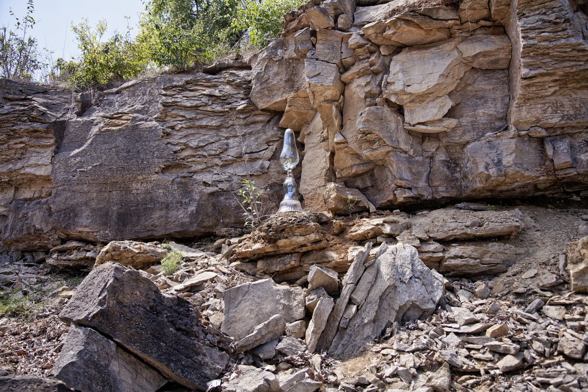
Artist Robert Goetz’ hand-blown, water-drop-shaped glass was the inspiration for this cairn. The glass contains a wild flower found at the site. The fissure in the limestone behind the Cairn shows how water flowing, freezing, and thawing can split the rocks. The resulting rocky rubble creates a rough soil where wind–blown seeds can take root and grow. The plant’s roots further break down the bluffs.
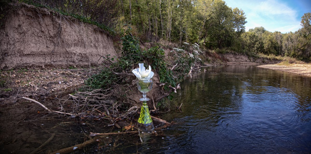
Courtois River near Leasburg, Missouri
N38.029614 W091.221042
September 2014
The cairn is balanced on a “raft” of sticks, caught by an island that is not much bigger than the beverage coolers in the passing canoes.
Created for the Open Space Council of St. Louis’ “Lower Meramec Hands-On Stewardship & Watershed Education” program, supported by a Five Star and Urban Waters Restoration Program grant from the National Fish and Wildlife Foundation and the U.S. Environmental Protection Agency.