

Badlands Loop Road near Conata Road, Badlands National Park, South Dakota, June 30, 2018
43° 50’ 59” N 102° 12’ 48” W-Elevation 2,800 feet
The Green-Gold Cairn, with its new green base and the addition of a tall bronze vase, was made for this spot to mark the yellow-orange rock strata and green vegetation. The unexpected green color was the result of more than usual rain in June and July.

Theodore Roosevelt National Park, southern unit loop road, North Dakota, July 2, 2018
46° 54’ 51” N 103° 26’ 12” W-Elevation 2,600 feet
No Egrets Cairn stands among fire damaged trees in the North Dakota Badlands.

Theodore Roosevelt National Park, Southern Unit North Dakota July 2, 2018
46° 56’ 01” N 103° 24’ 41” W-Elevation 2,500 feet
Parts of the Green Gold Cairn stand in front of a Badlands wall eroded to form monument-like columns in the southern unit of the Theodore Roosevelt National Park off eastern fork of the loop road,

Little Missouri River State Park, North Dakota, July 2, 2018
47° 33’ 01” N 102° 44’ 25” W-Elevation 2,400 feet
Little Missouri River State Park is a campground for families and their horses. This cairn a composite of Crystal and Clear cairn segments is located on a bluff overlooking the Little Missouri River that meanders hundreds of feet below in the expansive badlands.

Near the intersection of 38th Avenue SW and 12th Street
Fort Clark, North Dakota, July 2, 2018
47° 14’ 17” N 101° 17’ 55” W-Elevation 1,850 feet
After sunset near the confluence of the Knife and Missouri rivers looking east toward Stanton, South Dakota, where a line of red lights on the horizon marks wind turbines.

Near the intersection of 38th Avenue SW and 12th Street
Fort Clark, North Dakota, July 2, 2018
47° 14’ 17” N 101° 17’ 55” W-Elevation 1,850 feet
The same site as the Natural Power image, but looking west to Stanton, South Dakota, near the confluence of the Knife and Missouri rivers. The Basin Electric Cooperative Leland Olds Station, a coal-fired power plant, is seen in the distance on the right.

West Pollock Recreation Area, South Dakota, July 3, 2018
45° 53’ 03” N 100° 20’ 10” W-Elevation 1,640 feet
The West Pollock Recreation Area at the norther boundary of South Dakota has beautiful views of the Missouri River. But this tree that had survived many indignities from storms or man to thrive at the edge of the maintenance building parking lot was worth marking with a No Egrets Cairn segment.

Pollock, South Dakota, July 3, 2018
45° 45’ 26” N 100° 17’ 25” W-Elevation 1,990 feet
Crystal Cairn perches on the side of Leola River Road, overlooking the sunset in the valley below, one of the most beautiful places on the planet.

Phillip, South Dakota, July 4, 2018
44° 41’ 07” N 101° 13’ 52” W-Elevation 1,840 feet
The title of this image overlooking the Cheyenne River with the Green-Gold Cairn in front of a rusted farm implement, is taken from “Emily,” a song-story in the Ys album by Joanna Newsom.

Fort Pierre, South Dakota, July 4, 2018
44° 21’ 27” N 100° 22’ 42” W-Elevation 1,470 feet
A Crystal Cairn rests at the end of the parking lot at the Casey Tibbs South Dakota Rodeo Center and Mattie Goff Newcombe Conference Center overlooking a grain storage facility and Fort Pierre homes. The Missouri River separates this smaller city from Pierre, the capital of the state of South Dakota. The citizens of these two cities go all out for Independence Day Celebration fireworks.

255th Street and 341st Avenue, Chamberlain, South Dakota, July 5, 2018
43° 41’ 16” N 99° 22’ 17” W-Elevation 1,640 feet
The No Egrets Cairn sits in front of an abandoned house.The roof had partially caved in and the damaged part hung like a hammock suspended from the roof beams.When the wind blew, the house would emit a low-pitched sound as if a very large animal was snoring on the second floor.

Snake Creek Recreation Area Overlook, near Highway 44/50 bridge over the Missouri River, Platte, South Dakota, July 5, 2018
43° 23’ 35” N 99° 06’ 59” W-Elevation 1,500 feet
All along the Missouri River, there are many references to Lewis and Clark’s 1801–1806 historic journey in names of places and historic markers. The sign at this overlook indicates this is the place where “Shannon Shows Up.”
According to Wikipedia, Private George Shannon was the youngest member of the Corps of Discovery. During the fall of 1804, he was lost for more than two weeks and nearly starved to death.

471st Avenue, Elk Point, South Dakota, July 6, 2018
42° 40’ 15” N 96° 47’ 13” W-Elevation 1,090 feet
Vermillion is the name for an intense red color similar to the setting sun here on the Vermillion River, near the city of Vermillion, South Dakota.

260th Street, North of Hamburg, Iowa, July 7, 2018
40° 40’ 26” N 95° 42’ 54” W-Elevation 910 feet
The No Egrets Cairn sits on a gravel Road under a clear sky full of stars and the visible Milky Way.

St. Joseph Riverwalk, Francis Street
St. Joseph, Missouri, July 8, 2018
39° 46’ 04” N 94° 51’ 40” W-Elevation 940 feet
This clear, translucent, white-glass combination cairn sits under the Highway 229 bridge in downtown St. Joseph, Missouri. The cairn marks a jarring, but not uncommon, a minimally accessible urban riverfront where highway, train tracks, industrial buildings, and a pedestrian walkway through a restored quasi-natural habitat (partially visible on the left) coexist.

Wyandotte Lake County Park
Kansas City, Kansas, July 8, 2018
39° 09’ 25” N 94° 46’ 34” W-Elevation 830 feet
After sunset, the Clear-Glass Cairn sits among native grasses growing on the side of a creek flowing to Wyandotte Lake, while a long exposure photograph captures fireflies darting among the grass and trees.

Kaw Point Riverfront Park
Kansas City, Kansas, July 9, 2018
39° 06’ 57” N 94° 36’ 37” W-Elevation 940 feet
Looking across the confluence of the Kansas (also called the Kaw River) and Missouri rivers. This was the site of the Lewis and Clark encampment June 26–29, 1804. Now, it offers a stone table base for a cairn, with a great view of downtown Kansas City, Missouri, not diminished by the sight and scent of the city’s waste treatment plant (in the background on the right).

Missouri River Bottom, off Highway 1804 across the Missouri River from Huff, North Dakota, July 3, 2018
46° 37’ 34” N 100° 38’ 31” W-Elevation 1,610 feet
South of Bismarck, the Missouri River widens and is called Lake Oahe (pronounced oh-WAH-hee). This image was made on the east side of the Missouir RIver looking across the river to Huff, North Dakota

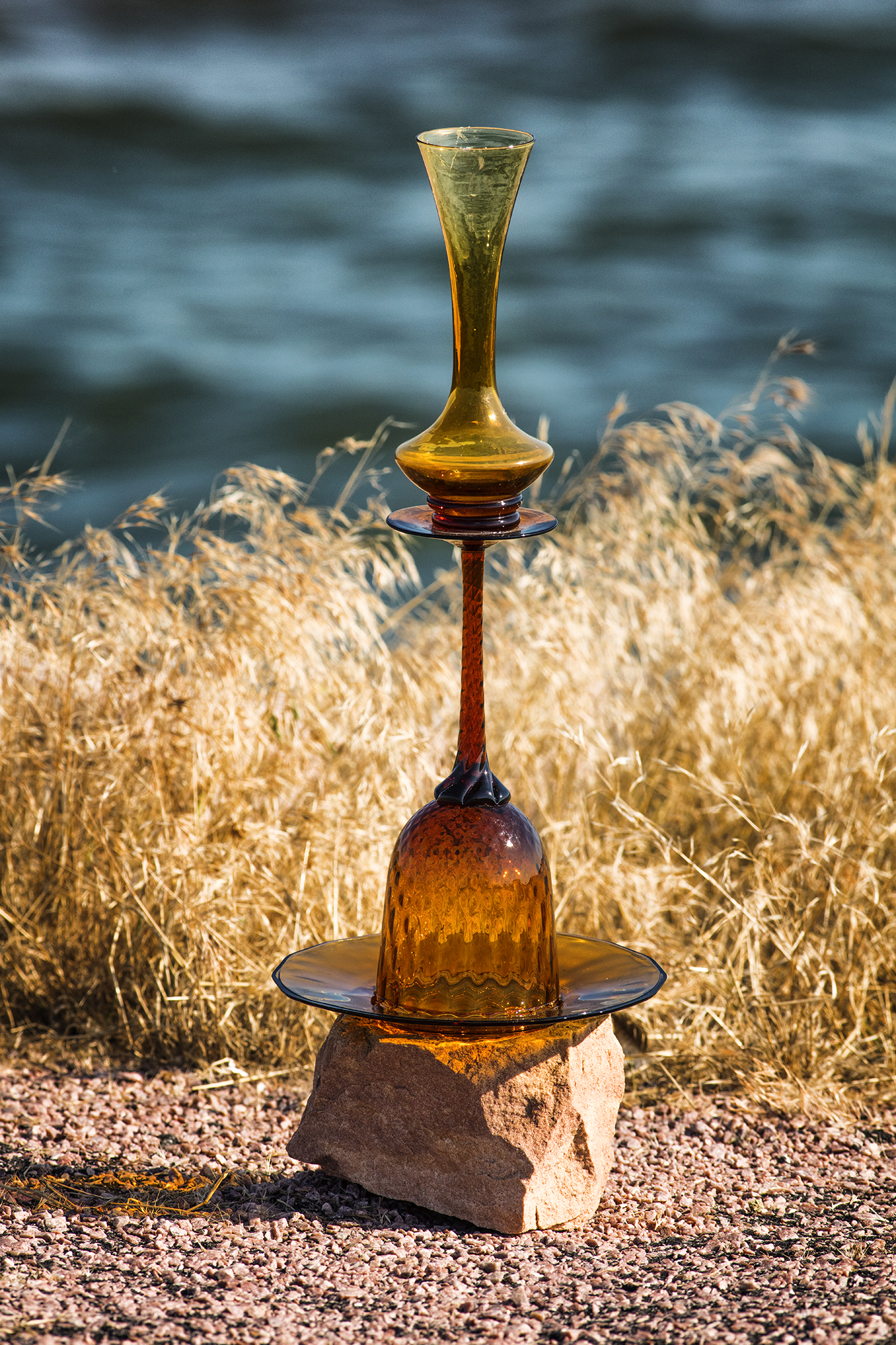
Badlands National Park, South Dakota, June 30, 2018
43° 45’ 18” N 101° 59’ 2” W-Elevation 2,390 feet
We arrived in Badlands National Park in the afternoon. It was raining, making the red layers of the moonlike rock formations stand out. We pulled out the Crystal Cairn, balancing it on an approximately seven-foot-tall rock, the consistency of semi-hard, slightly slippery concrete. We call this shot Bringing Down the Sky for the way the top vase blends into the colorless sky and for the raindrops.

Sioux River Road, Stone State Park, North Sioux City, Iowa, July 7, 2108
42° 33’ 24” N 96° 28’ 38” W-Elevation 1,090 feet
Josh saw a bald eagle fly away as we were unloading this Clear Cairn from the van. Unfortunately, the majestic bird did not return to its perch here on the Big Sioux River in time to be included in this image.

Revheim Bay Recreation Area, Mobridge, South Dakota, July 4, 2018
45° 31’ 06” N 100° 23’ 50” W–Elevation 1,590 feet
Mobridge was a busy place for a three-day rodeo July 3-5. A heavy storm swept through the area on the evening of the 3rd, felling trees and knocking down the festival’s circus-sized food tent. Many branches were down near the entrance to the picnic and children’s playground, but other areas, like the site of our shoot with the Clear and No Egrets cairn segments, were unscathed.

Decatur, Iowa, July 7, 2018
42° 0’ 26” N 96° 14’ 35” W-Elevation 1,080 feet
A large ceiling-light glass is used as a base for No Egrets Cairn segments. Motorists who stopped to talk with us explained that the bridge was closed during the 2011 flood because the ramp on the other side of the river had washed out, and all the land on this side was flooded.

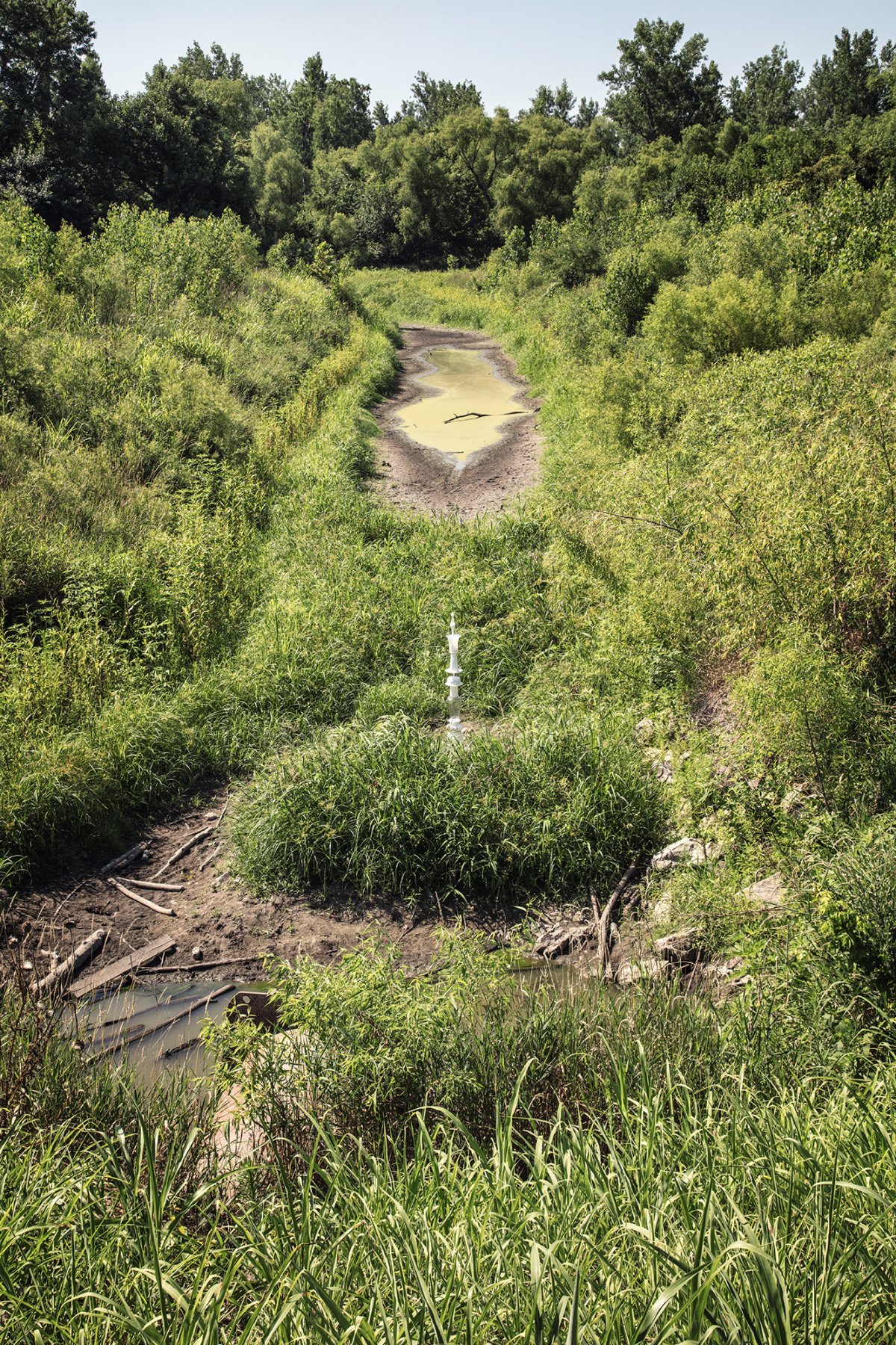
Three Rivers Wildlife Area, RIver Sioux, Iowa, July 7, 2018
41° 48’ 07” N96° 03’ 58” W-Elevation 1,070 feet
Erosion at the base of the False gods 2 Cairn on the bank illustrates one of the ways that rivers like the Little Sioux sculpt new channels.

False gods 2 Cairn on 48th Street, Plattsmouth, Iowa, July 7, 2018
41° 01’ 08” N 95° 59’ 17” W-Elevation 1,120 feet
Ahead the gravel road was washed out by 4-mile Creek on its way to the Platte River. The flooding must have been recent because a local man seemed surprised by the barricade. He drove carefully between the barricades, past the cairn, and down toward Ashland Road intersection at the bottom of the hill. The van’s taillights illuminated the road behind the cairn.

Spearfish Creek, off Highway 41A, after it is joined by Iron Creek, Black Hills, South Dakota, July 1, 2018
44° 22’ 41” N 103° 54’ 51” W-Elevation 4,780 feet.
Clear water tumbles over rocks in Spearfish Creek behind the Crystal Cairn. The dark green foliage of South Dakota’s Black Hills is in the background.

Fort Pierre, South Dakota, July 4, 2018
44° 21’ 27” N 100° 22’ 42” W-Elevation 1,470 feet
A composite cairn rests at the end of the parking lot at the Casey Tibbs South Dakota Rodeo Center and Mattie Goff Newcombe Conference Center in Fort Pierre, population 2,000. The view is across the Missouri River to Pierre, the South Dakota state capital, population 14,000. Although few in number, the citizens of the two Pierres go all out for Independence Day Celebration fireworks.

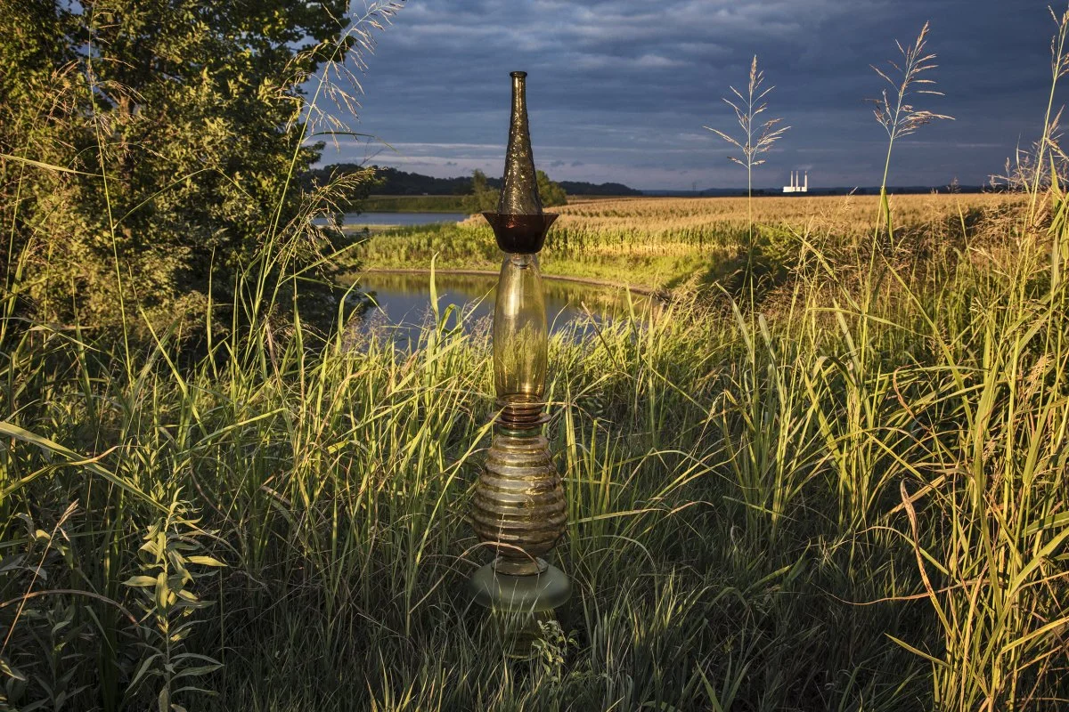
Theodore Roosevelt National Park, South Unit (near old east entrance) North Dakota, July 2, 2018
46° 55’ 49” N 103° 29’ 14” W-Elevation 2,540 feet
The False gods Cairn (version 2) is dwarfed by rock/hills off the East Loop Road in the Theodore Roosevelt National Park badlands.

Belle Fourche Reservoir, Belle Fourche National Wildlife Refuge, South Dakota, July 1, 2018
44° 42’ 34” N 103° 42’ 18” W-Elevation 3,050 feet
Near the Belle Fourche Reservoir, the largest body of river water in the area, this big field of native grass was waving in the wind. Leveling and balancing the 22-inch glass bowl-shaped light fixture and a No Egrets spire in a spiral of grass had its complications: Libby put her hand on a prickly pear cactus, and Josh was overrun by tiny ants as he sat in the grass to photograph the cairn.

Missouri River Natural Area and Trailhead
1472 River Drive NE, Mandan, North Dakota, July 3, 2018
46° 50’ 10” N 100° 51’ 52” W-Elevation 1,610 feet
Assembled on site from No Egrets and Clear segments to draw attention to the eroding riverbank, one of the sources of the sediment in the Missouri River, also known as “Big Muddy.”

Near the Intersection of Highway 1804 and Point of View Road
Pollock, South Dakota, July 3, 2018
45° 48’ 43” N 100° 17’ 11” W-Elevation 1,970 feet
A wooden fence, in front of a wind turbine in a cornfield, protects in-ground water pipes, a pump, and a cairn built from No Egrets and Clear cairns.

Old Agency Tribal Park, off highway 1804
Forest City Lakeside Use Area, South Dakota, July 4, 2018
45° 01’ 31” N 100° 18’ 14” W-Elevation 1,630 feet
Butterflies flit among the native plants on the shore at the Forest City Lakeside Use Area, near the confluence of the Cheyenne and Missouri rivers. The highway 212 Bridge is in the background.

Niobrara State Park, Niobrara, Nebraska, July 6, 2018
42° 46’ 10” N 98° 04’ 28” W-Elevation 1,520 feet
This cairn, assembled from sections of the Clear and Crystal cairns, rests at the top of steps leading down to bottomland created by the Missouri River and Mormon Canal. The site is a mile upstream from the point where the Niobrara River, a major tributary, enters the Missouri River.

Lewis and Clark Lake, East Street and 898 Road
Santee, Nebraska, July 6, 2018
42° 50’ 34” N 97° 50’ 17” W-Elevation 1,240 feet
No Egrets Cain perches at the end of a dock. Soon after we finished making this image, fishermen returned to the dock pleased with their catch and temporarily disturbing the mirror smooth lake surface pictured here.
Gavin’s Point Dam, Lewis and Clark Lake
Seven Miles West of Yankton, South Dakota, July 6, 2018
42° 52’ 16” N 97° 29’ 31” W-Elevation 1,220 ft.
The top of the Green-Gold Cairn marks the edge of the recreational lake created by the Gavins Point Dam near Yankton, South Dakota. The dam generates enough electrical power to serve 85,000 homes. This cairn doesn’t mark the hydropower; rather, it seeks to draw attention to the soil in this river known as “Big Muddy. if this sediment laden water were not contained by the dam, it would flow from the Missouri, into the Mississippi and on to the gulf of Mexico to slow the loss of the valuable Louisiana Delta.

446th Ave and 310th St., Michigan Hill, South Dakota, July 6, 2018
42° 53’ 39” N 97° 16’ 28” W-Elevation 1,240 feet
The James River is one of the Missouri River’s major tributaries. Flowing south from North Dakota to its confluence near Yankton, South Dakota, the muddy river irrigates rich agricultural land like this family farm.

Bigelow Park Road in Salix, Iowa, July 7, 2018
42° 18’ 23” N 96° 20’ 21” W-Elevation 1,050 feet
No Egrets Cairn sits at the southern end of an oxbow lake. Horseshoe-shaped lakes like this one were once part of an older river channel. When flooding, earthquakes, or erosion, caused the river to find a new channel, some water remained in the deeper parts of the old riverbed, creating a lake cut off from the river’s flow.

Iron Nation Road, Lower Brule, South Dakota, July 5, 2018
44° 10’ 50” N 99° 34’ 42” W-Elevation 1,490 feet
The No Egrets Cairn rests near a cylindrical bale of hay, close to the end of a peninsula created by a horseshoe-shaped bend in the Missouri River.

Powerhouse Road, Lake Andes, South Dakota, July 6, 2018
43° 03’ 39” N 98° 33’ 11” W-Elevation 1,160 feet
At night, the intense lights on Fort Randall Dam’s electrical power plant are almost too bright to look at. Built in the mid 1950s at 2.5 times its anticipated cost, the dam was generating 200,000 kilowatts of electricity in the 1970’s, four times the current output of the most economically efficient Big Bend Dam upriver. Oddly, the US Army Corps of Engineers hasn’t updated the energy output of the Fort Randall Dam for a current comparison.

Spirit Mound Historic Prairie
Vermillion, South Dakota, July 6, 2018
42° 52’ 03” N 96° 57’ 20” W-Elevation 1,220 feet
This mound is a geological feature created when the ancient glaciers leveled the surrounding land, skirting this rocky outcropping. Lewis and Clark visited the Spirit Mound in 1804, traveling on foot from their campground on the Vermillion River. https://gfp.sd.gov/parks/detail/spirit-mound-historic-prairie/

Trapper Ave., Brunswick, Missouri, July 10, 2018
39° 23’ 32” N 93° 05’ 44” W-Elevation 580 feet
The Clear-Glass Cairn, which had been used for the Hay, Corn, and Trees image, moved to the middle of Trapper Avenue, near the point where the Grand River, a major tributary, enters the Missouri River.

Near the point where the Niobrara River enters the Missouri River
Brownville, Nebraska, July 8, 2018
40° 23’ 32” N 95° 38’ 54” W-Elevation 890 feet
James Smith, inland marine pilot and co-owner of the River Inn Resort, including a twenty-five stateroom floating Bed and Breakfast, and a smaller charter riverboat, stopped rebuilding the road into the resort to talk with us.From the cab of his front-end loader, he explained that the land had been flooded with about 2.5 feet of water for a week.Mr. Smith said, “If you didn’t love it (working on the river), you’d go crazy.”

Weston, north of Kansas City, Missouri, July 8, 2018
39° 20’ 59” N 94° 52’ 07” W-Elevation 770 feet
The white-glass No Egrets Cairn tries to blend in with 6-foot-tall, vibrant green corn nearWeston, Missouri, north of Kansas CIty.

Arrow Rock, Missouri, July 10, 2018
39° 04’ 05” N 92° 56’ 37” W-Elevation 620 feet
The No Egrets Cairn perches on rocks over the Santa Fe Spring in the Arrow Rock State Historic Site. The town of Arrow Rock was a well-known landmark on the Missouri River, appearing on a 1732 French map as “Pierre a’ Flesche,” or rock of arrows. By the 1850s, the town was one of the busiest ports on the Missouri and with 1,000 residents. Now the town, a National Historic Landmark, has fifty citizens and hosts tourists visiting its historic tavern, homes, and beautiful state park.

Katy Trail Park, Rocheport, Missouri, July 10, 2018
38° 58’ 28” N, 92° 33’ 58” W-Elevation 580 feet
A cairn assembled from clear and crystal glass rests at the end of the riverwalk trail near confluence of Moniteau Creek and the Missouri River. Highway 70 bridge over the Missouri River is seen in the background.

South of Westover, South Dakota, June 30, 2018
43° 42’ 52” N 100° 40’ 22” W-Elevation 1,790 feet
We spotted the White River, a tributary of the Missouri River, as we crossed a bridge over US 83, not too far from highway 44. It really is white: the sand is white and the water is the color of a latte with way too much milk. Following a dirt road we had seen before the bridge, we caught up with the river resting in its flood plain. The NoEgrets Cairn holds the sky in its handblown, clear glass top.

Katy Trail State Park, Hartsburg, Missouri, July 21, 2018
38° 42’ 29” N 92° 20’ 24” W Elevation 550 feet
The cairn perches on a barrier rock at the edge of the parking lot and access to barges moored here. The No Egrets and Summoning Clouds combination cairn bears witness to the way the rules against fires and alcoholic beverages are disregarded.

Old Mill Road, Bonnots Mill, Missouri, July 21, 2018
38° 34’ 40” N 91° 58’ 01” W, Elevation 570 feet
Bonnots Mill is a charming town that looks like a shooting location for a film set in the 1930s. Near the Old Mill and adjacent to the train tracks, this small bridge allows water to run into the Osage River, 1½ miles before it joins the Missouri. The Osage River has its origin in the Missouri Ozarks.
Washington, Missouri, July 21, 2018
38° 33’ 27” N 90° 58’ 06” W Elevation 490 feet
The setting sun illuminates the Green/Gold Cairn and the corn in rolling fields off Augusta Bottom Road. The distant Labadie Power Plant gleams from those last, low rays. Unfortunately, the plant’s environmental record is not so shining.
In 2009, the plant was ranked the 22nd worst plant for its leaking coal ash pits. In another study in 2010, it was the 4th worst for its mercury pollution. In 2015 the Missouri Sierra Club contested the renewal of the plant’s operating permit because it did not specify a schedule for testing the water emitted by the plant. In 2016, the Environmental Protection Agency announced that the plant exceeded the National Clean Air Standards.

Ecopark, North Main Street
St. Charles, Missouri, July 27, 2018
38° 48’ 02” N 90° 28’ 15” W Elevation 440 feet
This 70-inch-tall white-and-translucent glass cairn sits on the Missouri River, north of the Highway 370 Discovery Bridge and the railroad bridge behind it. The 1993 flood destroyed most of the homes in this St. Charles, Missouri, neighborhood. Anticipating that the area was likely to flood again, the city bought and tore down the homes, turning this area on the Katy Trail into a river-access park with an ecological focus. Informational signage, benches, buildings, and trails are all built for easy restoration after the next¾inevitable¾flood.

Riverlands Way, Edward “Ted” and Pat Jones Confluence Point State Park, West Alton, Missouri, August 9, 2018
38° 48’ 58” N 90° 07’ 10” W-Elevation 470 feet
The Confluence Cairn rests on an octagonal concrete pedestal in Confluence Park. It is situated at the southern point of the peninsula that juts out between the Mississippi River, flowing from the east at the right of this image, and Missouri River, entering from the north on the left side of this image. The Missouri River has traveled about 2,350 miles from its origin in the Centennial Mountains, Montana, to the confluence. The Mississippi has journeyed 1,130 miles from its origin at Lake Itasca in northern Minnesota. The conjoined rivers become the Mississippi River from this point; it empties 1,190 miles downriver into the Gulf of Mexico, south of New Orleans, Louisiana.

Riverlands Way, Edward “Ted” and Pat Jones Confluence Point State Park, West Alton, Missouri, August 9, 2018
38° 48’ 58” N 90° 07’ 10” W-Elevation 470 feet
The Confluence Cairn rests on an octagonal concrete pedestal at the southern point of the peninsula that juts out between the Mississippi River, flowing from the east at the left side of this image, and Missouri River, entering from the west on the left side of this image. The Missouri River has traveled about 2,350 miles from its origin at in the Centennial Mountains, Montana, to this confluence. The Mississippi has journeyed 1,130 miles from its origin at Lake Itasca, Minnesota. The conjoined rivers become the Mississippi River from this point. The island on the horizon is situated in the middle of combined flow, now called the Mississippi. The Mississippi is joined by other rivers on its journey south before it empties 1,190 miles downriver into the Gulf of Mexico, south of New Orleans, Louisiana.

Riverlands Way, Edward “Ted” and Pat Jones Confluence Point State Park, West Alton, Missouri, August 9, 2018
38° 48’ 58” N 90° 07’ 10” W-Elevation 470 feet
Looking east across the Mississippi River, the Confluence Cairn glows in the dawn. The town of Hartford, Illinois, is in the background. The Missouri River joins the Mississippi just 30 feet south of this marker. Towboats and barges, like the one pictured here, will enter the Chain of Rocks Canal a mile-and-a-half downstream, while the Mississippi River flows over the Chain of Rocks shallow waters for about 10 miles downstream just north of St. Louis where the canal ends and commercial traffic returns to the river.
The Confluence Cairn, created from parts of other cairns used in upper Mississippi and Missouri River Watershed Cairns images,
Off Highway 210, Orrick, Missouri, July 10, 2018
39° 12’ 52” N 94° 11’ 38” W-Elevation 780 feet
The white No Egrets Cairn rests in the pool where water from adjoining farm fields drain into the creek at Jackass Bend.
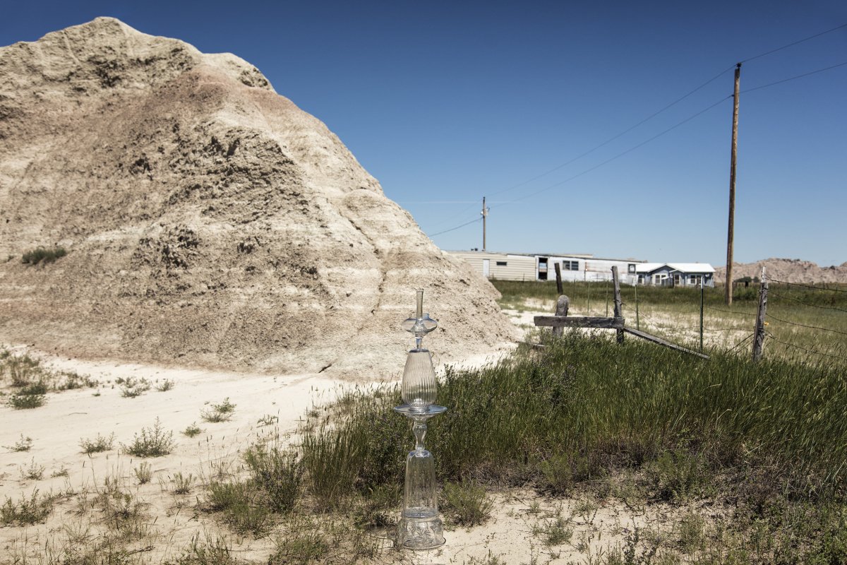
Main Street, Interior South Dakota
43° 43’ 43” N 101° 59’ 08” W, Elevation 2,370 feet
Interior, South Dakota, a city with a population 67 people, one peacock, and uncounted dogs and cats, was named for its position in the interior of the badlands.